
Re-Naturalization of Cities with Blue-Green Spaces
The Premise
Urbanization and construction of cities often worked towards a desertification of the natural landscape. This explosive 'industrialized 'urbanization, caused a struggle to balance the ecological/ recreational functions against the engineering functions(primarily of flood control) of the hydrological forms with the latter taking precedence. Consequently blue-green spaces soon receded under shades of gray of concrete and asphalt.
However, over the past couple of decades, cities have begun to implement projects to 'engineer' freeing up of these concrete channels to restore them to their dynamic natural state - thus effecting a 'RENATURALIZATION' of urban spaces. It is becoming a process of peeling back concrete and asphalt to daylight urban blue-green spaces and bring back the lost access to urban natural spaces. (1)
Lee In-keun, Seoul's assistant mayor who oversaw the Cheonggyecheon Stream Restoration Project, said that humans are reversing the cycle and going back to a human-oriented city from a car-oriented city. (1)
This narrative discusses this premise through the following project references. Each of these projects have a distinct design/ planning intervention in response to its context. The performance of some of these projects have been measured for different parameters and metrics. Figure 13 presents few of these to reflect upon the projects' success/ impact on effecting an urban renewal. Such measurements are a major breakthrough wherein the tangible ecological, social and at times more significant, the economic implications are able to be measured. These are important to further the proliferation of such projects.
The beauty of these projects lie in the paradox that, even though there are a lot of technical aspects of water management to integrate them into such urban parks, this is not obvious when looking at how relaxed and attractive the atmosphere of the park actually is.
Japan:
One of the most industrialized nations - Japanese cities peaked in the 70s-80s. The associated rapid loss of the natural ground to urbanization enlarged the area of impermeable landscapes, and increased flooding risks. Consequently, within a few years, most rivers were constrained and impounded to control flooding - thus worsening the depletion of natural ground. It was estimated that the wetland area had decreased by approximately 60% from the 1868 expanse. (2)
The energy crisis of 1970's paused this rapid economic surge. It was then that people , slowed from their frantic pace, began to recognize the value of natural landscapes and good living conditions. In all urban and suburban areas, rivers provided the last remaining open space for amenities and recreation. Shin-sui—'playing with water'—became popular and sought after. Numerous shin-sui parks were opened along rivers. Although these projects were conducted for recreational rather than for ecological purposes, they helped to turn people's attention back to nature. People acknowledged the importance of nature conservation and restoration. It marked the beginning of the cities need for such spaces (2). Within a decade river restoration projects proliferated rapidly as shown in figure 1.
Japan soon was amongst the pioneers of this process to re-naturalize its urban blue-green spaces. Its larger success lied in its ability to create an effective policy driven framework of collaborative effort to nurture these projects holistically rather than projects executed in isolation. The Japan River Restoration Network (JRRN) was formed which later on participated to form the Asian River Restoration Network (ARRN) through which Japan continues to share its knowledge and expertise with other Asian countries. (3)
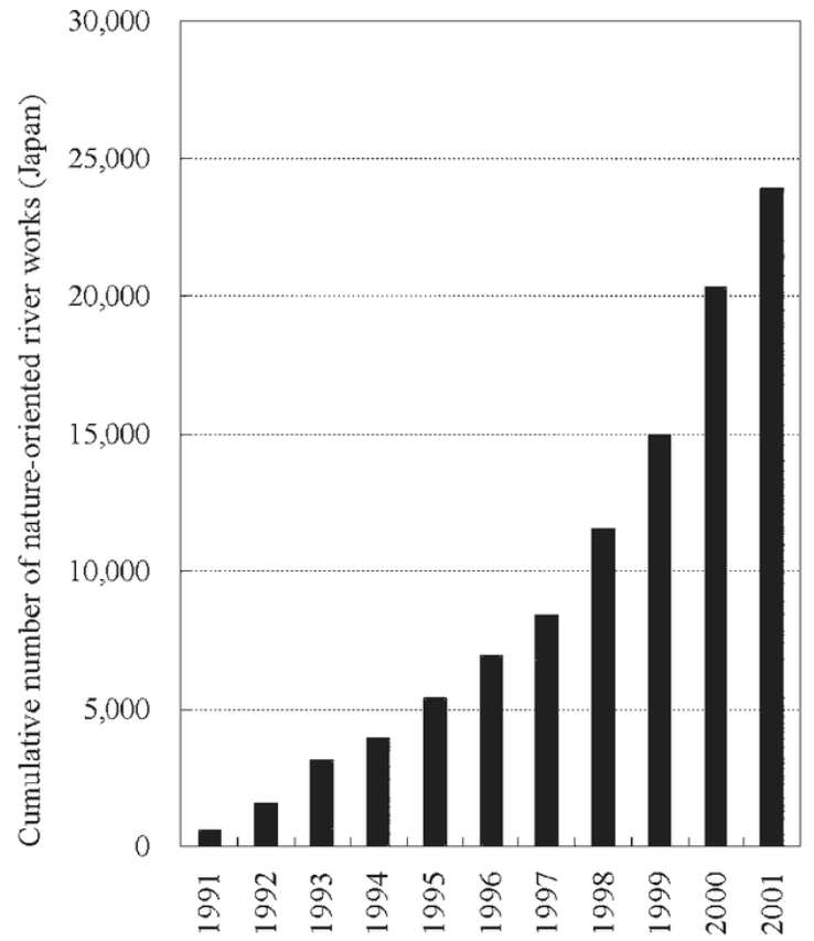
Figure 1: Graph Depicting the proliferation of river restoration projects in Japan over a decade.
Image Source: Published in the report 'River and Wetland Restoration: Lessons from Japan' by Keigo Nakamura, Klement Tockner and Kunihiko Amano published in Oxford Journals. (2)
Korea:
Similar in its collaborative and policy enabled program to Japan, Korea has also been able to reverse and regain its urban blue-green spaces. The most spectacular and profound have been the Yangjaecheon and the Cheonggyecheon projects by Seoul city.
The Cheonggyecheon Stream Restoration Project - from an underground sewer to an urban park.
Location - Cheonggyecheon Stream, Seoul, South Korea.
Size - 100 acres 3.6 miles (5.84 km) long
Budget - approx. $380 million USD
Landscape Design Team - SeoAhn Total Landscape (4)

Figure 2: Image on the left shows the restoration works in progress along the Cheonggyecheon; Image on the right shows the present day stream as a public space resplendent with restored biodiversity.
Image Source:
http://alfa-img.com/show/cheonggyecheon-before.html (open source image sharing website)
This historical waterway had been the 600-year old capital's centerpiece. However the Industrial era, following the Korean War - starkly degraded Cheonggyecheon and its network of tributaries to an open sewer (5). Concrete encased this three miles long sewer stream which was later covered by pavement and forgotten beneath a network of elevated expressways as the city’s population swelled towards 10 million. It took 50 years and a $384 million (5) recovery project to engineer one of the most stunning 're-naturalization' projects which day-lit the Cheonggyecheon.
Four years after completion, the impact of the project were ascertained (refer figure 13). The results established the project as a major breakthrough. An analysis by researchers at the University of California, Berkeley, found that replacing the highway with the walk-able greenway caused nearby homes to sell at a premium after years of going for bargain prices by comparison with outlying properties (5). This was a vindication from the initial staunch opposition the project faced from merchants and residents around the area who feared the loss of clients and property value from the removal of the elevated expressways. Data show that the ecosystem has been greatly enriched with a proliferating biodiversity and the micro-climate along the stream has improved the ambient comfort conditions for the residents. The project also displayed a comprehensiveness of planning as it substituted the lost expressway with an efficient BRT system.
Tangshan Nanhu - salvaging a waste land.
Location - Tangxu Road, Lunan, Tangshan, Hebei 063000, China.
Size - 1,557 acres
Budget - approx. $68 million USD
Landscape Design Team - Beijing Tsinghua Urban Planning and Design Institute (6)

Figure 3: Image shows the restored Nanhu area - the stable Northern part which has several spaces open for visitor access.
Image Credits: Beijing Tsinghua Urban Planning and Design Institute
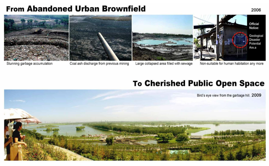
Figure 4: A series of compiled images shows the transformation from an industrial wasteland to a restored ecological area.
Image Credits: Beijing Tsinghua Urban Planning and Design Institute

Figure 5: Images shows the restoration works in progress and the re-use of materials salvaged from the site.
Image Credits: Beijing Tsinghua Urban Planning and Design Institute
Located in northeastern Hebei Province, 154km to Beijing, mineral rich Tangshan city was one of the cradles of modern China's industrialization drive (most of the underground mines were located 1km south of the city centre in Nanhu where this project is situated) (7). Its mineral resources, especially coal propelled its population increase and urban expansion. However construction of critical/essential infrastructure inconspicuously either lagged behind or were missed in the process.
Unabated mining for almost 50 years, exacerbated by large land subsidence (as well as the 7.8 magnitude earthquake in 1976) transformed the area into a devastated wasteland filled with waste dumped mounds - rendering it unfit and dangerous for habitation - a 180 degree turn-around for the once burgeoning city. By 2006, the subsidence area had grown up to 28 km2 (7). Nanhu thus become a 'restricted zone' in Tangshan’s urban development. The transformation of Tangshan-Nanhu from this state, under a collaborative effort led by the Beijing Tsinghua Urban Planning and Design Institute, to the present eco-city is impressive at the least.
Given the extremely stricken context of its existence, the rehabilitation works comprised of technological/ engineering interventions to alleviate ecological problems while providing for human requirements and focused especially on the use of materials. Given its existence as a waste dump - onsite waste materials were used as much as possible. The project also addressed the critical agenda to technically reform any waste which could lead to secondary pollution in the future (7). The economic savings from this was considerable. (refer figure 13).
The project divided the area into two distinct parts:
The geologically stable Northern part is designed as an active and vital public space, featuring large natural landscape construction and public recreational functions. A variety of services and activities are provided to build comfortable recreational environment including a revitalized garbage mountain, botanical gardens, central plazas etc. (7)
The worst affected and geologically derelict Southern part is designed as a natural reserve to protect and recover part of the regional ecosystem, retaining its natural landform and vegetation with minimal facilities and interventions. The planning limits the number of visitor footfall in order to maintain an environment favorable to plants and animals. (7)
Post project measurements indicate a considerable effect on the micro-climate (refer figure 13). The green cover too has increased significantly to 44%.
Floating Gardens, Yongning - demonstrating an ecological alternative to conventional flood control methods.
Location - Yongning River Park, Taizhou City, China.
Size - 21 hectares
Landscape Design Team - Turenscape (8)

Figure 6: Image shows the concrete encased river channel prior to the project's commencement.
Image Credits: Kongjian Yu, Turenscape
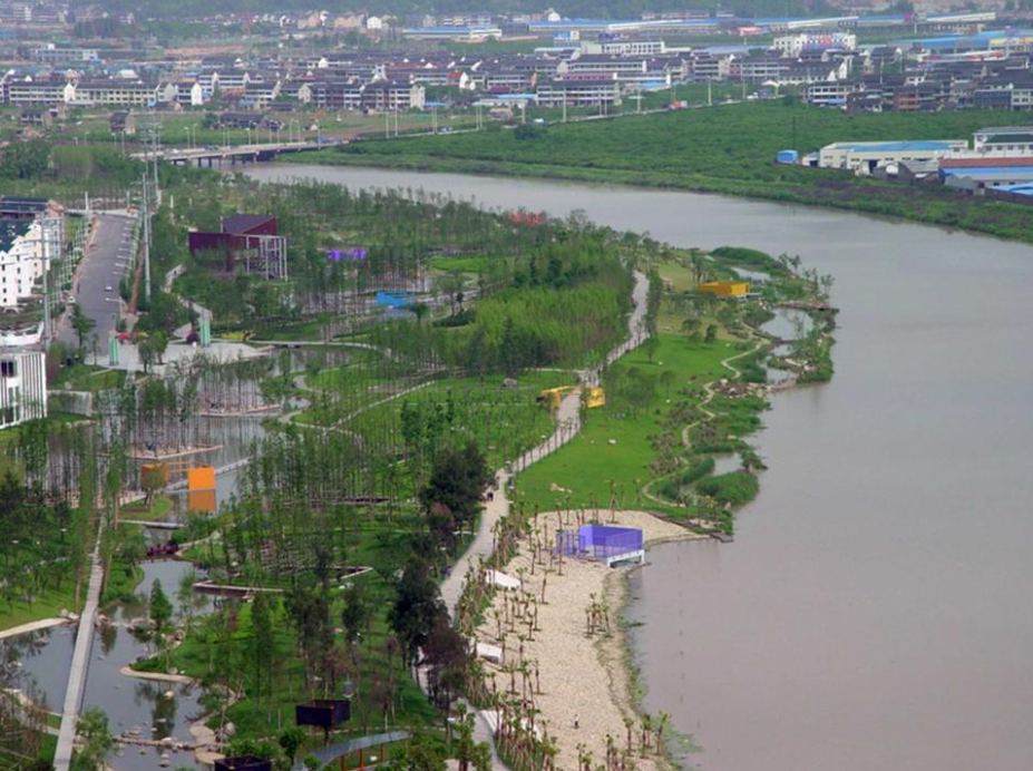
Figure 7: Aerial view of the completed project shows the riparian and outer wetlands and the network of green spaces and pathways.
Image Credits: Kongjian Yu, Turenscape

Figure 8: A series of diagrams show the overlapping matrices of elements which form the overall master-plan.
Image Credits: Kongjian Yu, Turenscape
This project presents an example wherein the design team (Turenscape) initiated an effort to convince local authorities to forego conventional concrete embankments for flood control and instead treat the landscape more than a mere cosmetic application; rather as an ecological system which provides the requisite flood control and storm water management measures while making the same accessible for visitors to experience the landscape as a pedagogical eco-system rather than a park. In doing so it also prevents the destruction of the edge conditions of the inter-tidal zones with expensive concrete embankments. (8)
The design comprises of two matrices overlapping each other (figure 8 ) (8). The first matrix is the hydrological aspect of the design response based on the natural regional drainage pattern. As part of this, the already constructed concrete embankments were replaced with restored riparian wetlands along the flood plain and an outer wetland lake outside the river bank and parallel to the river. During the monsoon season, both the wetlands are flooded to mitigate rising water levels whilst during the dry season the outer wetland lakes remain submerged from the retained water and water from inlets in the upper reaches of the park. This system makes water a year-round integral part of the park and accessible to the visitors. (8)
The second matrix is a network of paths, natural groves and floating pavilions which weave along the natural riverbanks salvaged from the concrete embankments and occasionally extending above the wetlands as a series of story boxes which contain information panels to help people learn and experience the natural ecological and hydrological processes as they meander through. (8)
This project successfully demonstrated a ecological approach to flood control and the results substantiate the same. Flood problems have been successfully addressed; several species of frogs, fish, and birds have returned to the area and hundreds of thousands of people visit to appreciate what would have been a cosmetic landscaped park.
Houtan Park - restoring an industrial brownfield as a regenerative urban living machine
Location - Pudong, Shibo Avenue, Shanghai, China.
Size - 34.5 hectares
Budget - approx. $15.7 million USD
Landscape Design Team - Turenscape (9)
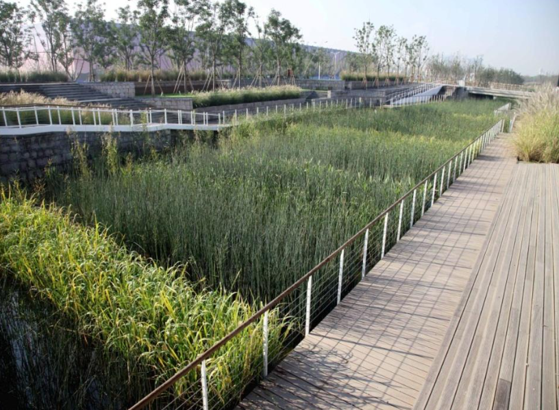
Figure 9: Terraced wetlands planted with crops and wetland species. A series of decks, pathways, steps negotiate the elevation changes and allow visitors to walk along a seamless boundary with the wetlands.
Image Credits: Kongjian Yu, Turenscape

Figure 10: The diagram shows the series of cascading water cleansing terraces of the wetlands. The water entering is of Grade V quality which is cleaned to Grade II - a visibly marked difference as shown here.
Image Credits: Kongjian Yu, Turenscape
Built as a part of the 2010 Shanghai World Expo, it is a restoration of an industrial brown-field site. The design approach is based on two paradigms:
restoration - via a series of wetlands which treat the polluted river water and
regeneration - making the site a living system providing multi-fold functions of food production, flood protection, water treatment and habitat creation together with leisure. Similar to the Yongning Project, the design team of Turenscape, envisioned three overlapping matrices for the design. (10)
The first is a linear constructed wetland, 1.7km long and 5–30 metres wide. This living machine treats the contaminated river water (figure 10). The series of cascades and terraces oxygenate the nutrient rich water, remove and retain nutrients and reduce suspended sediments whilst creating experientially aesthetic water features. Field tests indicate that 2,400 cubic metres of water can be treated from Grade V to Grade III per day (9). These wetlands also provide the buffer for flood protection between the 20-year and 1000-year flood control levees and helped replace the concrete floodwall to allow for habitat-friendly riprap that facilitates native species to grow along the riverbank.
The second matrix overlapping the wetlands are features representing the agricultural and industrial past of the site. The terraces of the wetland are planted with crops and wetland species (figure 9). These terraced agricultural landforms, reminiscent of Shanghai's agricultural heritage, allow visitors to witness a seasonal transition to the landscape. They also serve the purpose of alleviating the elevation differences along the park and from the bank to the water. The industrial spirit is retained using the reclaimed structures and materials from the erstwhile industrial structures.
The third matrix is that of a network of paths which weave together the recovered landscape, urban agriculture and industrial remnants. The paths interspersed with numerous nodes allow seamless connections to the different features of the park. Groves of bamboo and Chinese redwood trees act as screens along the paths to break up the spaces. (10)
Marikina River Restoration Project - culmination of sustained policy driven interventions to transform life along Philippines waste ridden rivers.

Figure 11: Typical derelict condition of rivers and streams in the urban areas of Philippines. Garbage and informal settlement structures populate the eroding river banks.
Image Credits: VJ Villafranca / Greenpeace

Figure 12: The result of the 'Save the Marikina River' project is visible along a certain segment of the river. The river and river banks have been restored to an engineered natural state providing access to nature and recreational spaces for the visitors.
Image Credits: Jassey Dela Paz-Estorninos (https://yessaj.wordpress.com)
This restoration project exemplifies the intent and effort needed on part of civic authorities to alleviate urban water bodies in abject decadence typical to the region. Its programme illustrates the challenges typical to developing countries dealing with rehabilitating informal settlers along river banks, affecting flood control measures and preventing waste discharge to urban hydrological bodies.
The former festive grounds of the Marikina river was all filth and stench by the 1970s owing to unbridled urban sprawl (11). The related informal settlement structures together with indiscriminate waste dumping into the river severely worsened the then prevailing flood problem. It was only as a response to this worsening flood problem that in 1993 'Save the Marikina River' programme was envisioned and broadened later to revive the water quality and its environs. (11)
The programme comprised of 4 distinct initiatives (11): First - build access roads to the river and undertake massive clearing and cleaning operations. Second - rid the river banks of the encroaching informal settlement structures which was the biggest challenge. The government used recurring massive flood events as the opportunity to evacuate the settlers and then housed them in resettlement areas. This was a visible advantage for the settlers too and thus prevented them from reverting. Existing laws permitting new structures and demolishing illegal structures were 'honestly' implemented. The smart part in this was the inclusive employment of the former informal settlers into the government teams monitoring future illegal structures. These efforts were then coupled with the Government designating the riverbanks (which is the river’s floodplain) as recreational land. Such designation prevented construction of buildings and allowed the river to enter its floodplain without hindrance. Third - industries were strictly forced to set-up ad maintain on-site water treatment facilities. Fourth - rehabilitation of the natural interface of the river as a place of leisure and opportunities.
These efforts bore their results a decade later. The following recorder observations illustrate the project's success:
Improved living condition of the resettled informal settlers who now have access to all basic services, infrastructure and even communal facilities.
The local government improved its waste management system and boasts a waste collection efficiency rate of 98%. (11)
Flooding has been significantly reduced from that which earlier covered about 27.52% (6.4 km2) of the entire city in 1992 to 19.04% or 4.4km2 in 2004 (11). Flood waters also recede much faster owing to the cleaning up of the river channel.
The World Bank and National Disaster Coordinating Council (2004) reports that the improved ambient quality indirectly benefitted the civic body from higher property tax revenues resulting from a 10-fold rise in property values.
Ironically - this still remains the only successful river restoration project in the country. Worse still, the efforts remain confined and concentrated to Marikina city alone and has not been expanded to the whole River basin. In 2010, the Pasig River restoration project was initiated in Manila and bears resemblance to the Marikina River Project.
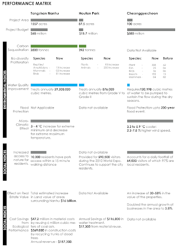
Figure 13: The table compiles the measured/ observed performance indices of three of the discussed projects.
Data Source: (7), (9), (4), (6)
Challenges and Opportunities :
Such Blue-green projects assume significance in the Asian context, which according to the UN-Water World Water Developing Report (2) have amongst the most polluted water bodies in the world, especially in their sprawling urban districts. These projects in urban areas involve maximum challenges and ecological and socio-economic constraints but hold considerable opportunities as well:
a. Conventional rehabilitation projects commonly involve measures like restructuring of banks, construction of in-stream structures or local widening and concrete embanking which are solely aimed to address flooding issues (2). However, such projects, as demonstrated in the projects discussed, have immense potential to significantly affect both the social and economical realms of urban living.
b. Developing countries struggle hard to grapple with economic and budgetary constraints for such restoration projects. The economic benefits/ impact measured from such executed projects must support future projects to tide over similar impediments.
c. Also of significance is the need for strong policy mandates and collaborative efforts. In the case of Japan and South Korea, the initiation of restoration projects and their successes cascaded into successful implementation of several projects across the country. Furthermore, these efforts were consolidated and channelized into a collaborative framework through organizations like the ARRN which is now guiding projects across Asia. Similarly mandates of the Public Utility Board (PUB) in Singapore are being implemented nationwide through the Active, Beautiful and Clean (ABC) waters programme. Successful projects like the Bishan-Ang Mo Kio Park, the Pungoll Waterways have garnered public support and interest for more similar projects.
d. Caution must be taken however of the pace of execution of these 're-naturalization ' projects. Many a times, tight commercially driven timelines and lack of maintenance costs/ programs put such hurriedly executed projects into disrepair soon after. Observers have commented the same for the Houtan Park project in Shanghai which was rushed to meet the 2010 World Expo deadline (12) . Projects would need diligent execution and continuous maintenance for their sustenance.
Worldwide the number of blue-green projects are proliferating exponentially. As David Gissen suggests the process of contemporary urban reconstruction includes the focus on recovering the hydraulic performance of the traditional which implies the consideration of rainwater and run-off as an asset for the city rather than a liability to be drained away as soon as possible. (13)
Bibliography
1. Andrew C. Revkin. Peeling Back Pavement to Expose Watery Havens. The New York Times. [Online] July 16, 2009. http://www.nytimes.com/2009/07/17/world/asia/17daylight.html?_r=0.
2. Keigo Nakamura, Klement Tockner and Kunihiko Amano. River and Wetland Restoration: Lessons from Japan. Oxford Journals. [Online] http://bioscience.oxfordjournals.org/content/56/5/419.full.
3. Asian River Restoration Network Annual Report 2007. Tokyo : Asian River Restoration Network Secretariat, Technical Coordination & Cooperation Division Foundation for Riverfront Improvement and Restoration (RFC), 2007.
4. Cheonggyecheon Stream Restoration Project. Landscape Performance Series. [Online] Landscape Architecture Foundation. http://landscapeperformance.org/case-study-briefs/cheonggyecheon-stream-restoration.
5. Removing Freewways - Restoring Cities; Seoul, South Korea Cheonggye Freeway. [Online] The Preservation Institute, 2007. http://www.preservenet.com/freeways/FreewaysCheonggye.html.
6. Tangshan Nanhu Eco-city Central Park. Landscape Performance Series. [Online] Landscape Architecture Foundation. http://landscapeperformance.org/case-study-briefs/tangshan-nanhu-eco-city-central-park.
7. Jie Hu, Youfeng An, Lushan Lu and Xiaofang Lu. FROM BROWN TO GREEN, A CASE STUDY OF NANHU ECO-CITY CENTRAL PARK LANDSCAPE PLANNING IN TANGSHAN, CHINA. IFLA APR Congress - Hospitality: The Interaction with Land, Bangkok Thailand : s.n., 2011.
8. Make Friends with Floods: Yongning River Park (The floating gardens). Descroll. [Online] October 16, 2014. http://www.descroll.com/design/make-friends-with-floods-yongning-river-park-the-floating-gardens.
9. Shanghai Houtan Park. Landscape Performance Series. [Online] Landscape Architecture Foundation. http://landscapeperformance.org/case-study-briefs/shanghai-houtan-park#/sustainable-features.
10. Turenscape - Architecture, Landscape Architecture, Urbanism. [Online] http://www.turenscape.com/english/projects/http://www.turenscape.com/English/projects/project.php?id=323.
11. Flood Disaster Mitigation and River Rehabilitation by Marikina City, Philippines - Case Studies on mitigating disasters in Asian and the Pacific. s.l. : Asian Disaster Preparedness Center, 2008.
12. Sabella, Lisa. Contemporary Landscape Architecture in China: Beautiful or Dangerous? Landscape Architects Network. [Online] April 23, 2014. http://landarchs.com/contemporary-landscape-architecture-china-beautiful-dangerous/.
13. Vives, Carolina González. Visualizing Urban Hidrology - The Design of a Wet Surface. Mas Context. [Online] 2012. http://www.mascontext.com/issues/15-visibility-fall-12/visualizing-urban-hidrology-the-design-of-a-wet-surface/.